Spatial Data Infrastructure (SDI)
A Spatial Data Infrastructure (SDI) is a combination of policies, standards and software to manage and deliver geospatial data 1. A good SDI follows policies and standards that are (widely) accepted in the communities (e.g. FAIR, OGC).
Although often providing new functionality, the main advantage of an SDI is the connection of different tools and software products to build (mostly) automated workflows. This allows for less manual processing (and therefore fewer errors) as well as standardized data products due to fixed workflows. For this to work flawlessly, extensive documentation and user instructions are key.
The SDI can contain (but is not limited to) data storage, metadata catalogue, tools for data processing, WebGIS and a form of data access (e.g. download, web service).
Examples of SDI's
SDI at UFZ
Publication
Schulz, C., Lange, R., & Bumberger, J. (2023). spatial.IO - An integrated cloud-ready geospatial data management system. Zenodo. https://doi.org/10.5281/zenodo.10391523
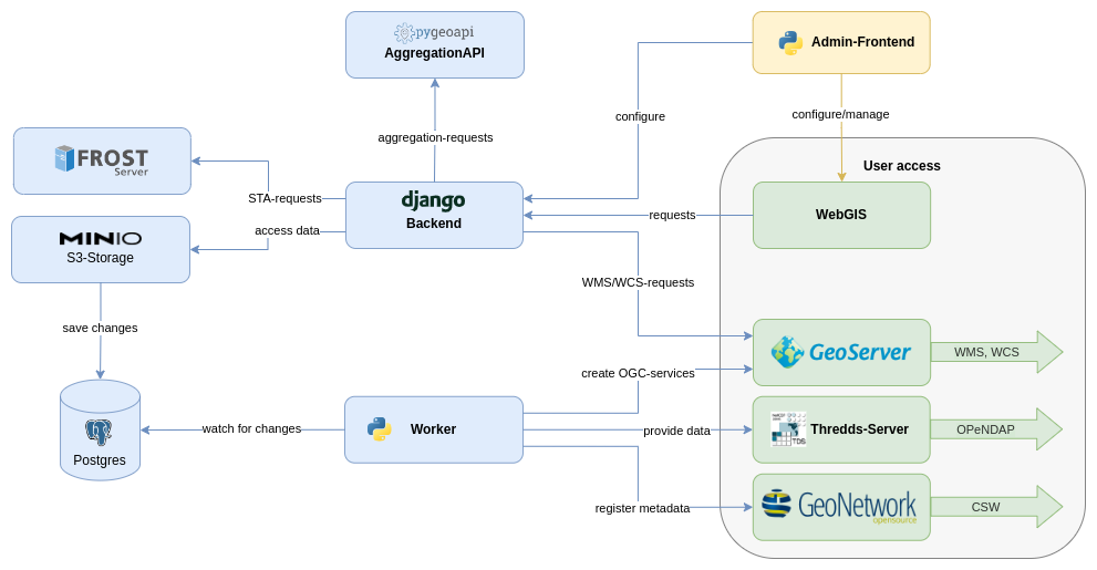
The SDI at UFZ combines multiple existing software products with own additions to accomplish automated workflows for (meta-)data storage, management and delivery. RDM Guidelines provides specifications on how to get your data into the SDI as well as SOP's to ensure flawless workflows for users. Additionally, a list of standards provides information on necessary prerequisites for the SDI to work as expected.
Why should I use the SDI at UFZ?
The SDI at UFZ provides multiple functionalities and tools to store and deliver your data. By registering your data to the SDI, you get access to our storage MinIO, which you can access from anywhere.
Depending on your requirements, you can then use all or just specific workflows and tools of the SDI to make your data available inside or outside UFZ via WebGIS, web services (GeoServer, THREDDS Server) or direct access (MinIO, GeoNetwork).
SDI components
| Name | Description |
|---|---|
| MinIo | https://minio.ufz.de
|
| WebGIS | https://web.app.ufz.de/gdi/
|
| THREDDS Data Server (DTS) | https://gdi-fs.ufz.de/thredds/catalog/catalog.html
|
| GeoServer |
|
| GeoNetwork |
|
| Backend |
|
Workflows and SOP's
Workflows:
Standard Operating Procedures (SOP's):
Documentation
Management:
Standards and prerequisites:
-
Simmons, Scott: Comprehensive Geographic Information Systems (2018), pp. 110-124. https://doi.org/10.1016/B978-0-12-409548-9.09611-1 ↩